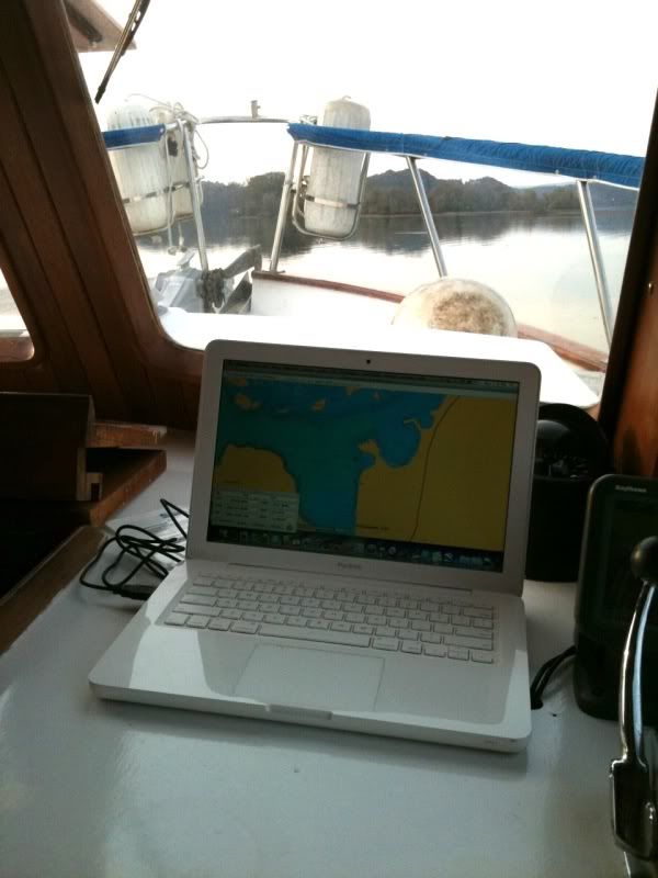
When we bought our trawler, she was minimally equipped with electronics. All she really had was a 2 station VHF radio (upper and lower helm), fish finder (one at each helm station which also acts as a depth finder) and well, that is about it. That was no problem when we were on Lake Lanier in Atlanta- it was a very large lake but we knew it well from years of spending our weekends on the water there and had no need for GPS or anything to safely travel the lake.
However, moving to the Tennessee River would be essentially new cruising grounds for us (granted, we had done 450 miles of the river 2 previous boats ago in our 33' express but that was just passing through) and we wanted to make sure our family was safe. Thus the search was on for the must cost effective solution to implement a reliable GPS navigation system. There were several options:A) Purchase a standard marine GPS chartplotter from a company such as Garmin or the like. Their a multitude of functions and features available with them and they have screen sizes from about 4" to 12". Obviously the larger the screen, the easier it is to see what is on the chart. A small 4" screen unit easily costs $600 and a larger screen unit can go up to about $7,000. YES- $7k for a GPS:
http://www.westmarine.com/webapp/wcs/stores/servlet/ProductDisplay?productId=130272&catalogId=10001&langId=-1&storeId=11151&storeNum=10103&subdeptNum=10268&classNum=10269
Crazy. Obviously we needed to come up with a solution that would result in the largest screen possible for the lowest cost. We sure weren't about to spend multiple thousands of dollars on a GPS.
Enter my Macbook laptop!
Many cruisers have utilized laptops for GPS navigation for a while. Most are using PC/Windows platforms. When doing so, the general advice is to use the machine that acts as the chartplotter strictly for navigation and never, ever use it to surf the net, etc. The reason for this clearly is the threat of catching a virus and shutting down your only ability to safely plot a course. Thankfully, I switched to a mac about a year and a half or more ago so I don't have to worry about viruses. Using my macbook would allow me to have a very large screen (compared to regular marine GPS units) and a very stable platform to run a GPS program. There are several programs available for PC units (such as OpenCPN at www.opencpn.org) but not as many available for macs. Thankfully, the folks at MacENC have created a great navigation platform exclusively for the Mac so that is the program we went with.
MacENC gives us the charting program but with that we need an actual GPS unit and the right charts. A simple USB GPS Puck is all it takes to get GPS tracking. They cost less than $35. Here are some on Amazon. If you are coastal cruising you can just download the free NOAA official coastal charts. However, charts for the TN River are from the Corps of Engineers. In looking around, the Navionics Charts have more detailed info so we spent the extra money to get their charts (about $150). At this point we're up to a few hundred dollars. But like the infomercials on TV, order now and we will double your order!
As great as having my macbook act as the GPS program, reality is that I don't want to exactly have my laptop up on the bridge in the rain and bad weather. Thankfully, our lower helm is fully enclosed with heating and air conditioning so we are left with just the bridge. Thanks to some discussions with a few other boating friends, we landed on a win-win solution and that is...dual screen monitors!
There is a wiring run right next to the lower helm that goes up to the bridge. I bought a long VGA extension chord that was 15' long. One end sits at the lower helm station, the other end was run up to the upper helm. I brought my 15" flatscreen computer monitor from the office (perfect excuse to upgrade to a larger screen at the office). The screen up on the bridge can then be plugged into my macbook and everything viewed from the bridge. Along with this, I bought a small wireless mouse. Amazingly, it transmits through the flybridge floor down into the cabin below and I can control the laptop in the cabin from the bridge. Due to the cold weather this winter I have not permanently installed the mounting base for the flybridge flatscreen but I have dry fit it all and confirmed it all works. Once spring is here and it's actually nice enough to cruise from there I will finish installing the fixed base.
Not only do we now have dual, large screen GPS chartplotting capacity on our trawler, but I can check my email on it too!


No comments:
Post a Comment